GeoVITe – Geodata Visualisation and Interactive Training Environment
Summary
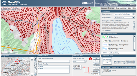
GeoVITe is currently the geodata portal for the ETH Domain. Originally started as an online learning platform in 2004, GeoVITe (GEOdata Visualisation and Interactive Training Environment) offers since 2010 a better solution for the distribution of (swisstopo) geodata to the researchers: a visual, easy-to-use and online accessible option to the traditional file system distribution. Presented to the end user in an interface designed with SVG and empowered with Javascript functionalities, the geodata is grabbed by visualization and geoprocessing services from our servers and made available for exploring and download. Beginning with 2015, GeoVITe is part of the bigger project Geodata4SwissEdu, coordinated by the ETH Library.
Kick off
01.07.2004
Researchers
Lead: Hurni, Lorenz
Internal: Iosifescu Enescu, Cristina. Iosifescu Enescu, Ionuț. Heitzler, Magnus
Funding sources
ETH internal grant