Geodata4SwissEdu
Summary
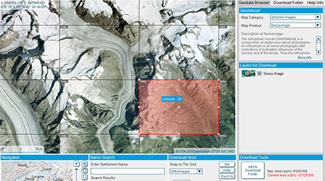
Geodata4SwissEDU is a user-oriented service for search, access, presentation, download and processing of geo-information for research and education at Swiss universities and universities of applied sciences. It is based on two existing services: GeoVITe, operated by the Institute of Cartography and Geoinformation at ETH Zurich in collaboration with the ETH library; and the Competence Centre Geo-information of the University of Applied Sciences Rapperswil (HSR). It aims at developing a comprehensive service which can be used not only by cartographers or GIS specialists but also by other domains relying on geo-data, such as geomatics in general, architecture, civil engineering, environmental engineering/sciences, earth sciences, etc. Central aspects and aims of the project are: an extended geo-data offering (federal, selected cantonal and project-specific data), the implementation of a scalable technical infrastructure, and the development of user-oriented geodata management functionality. A long-term operation concept will ensure the sustainable use and further development of Geodata4SwissEDU.
Project period
01.01.2015 – 31.03.2018
Researchers
Lead: Piguet, Arlette
Internal: Iosifescu Enescu, Cristina. Iosifescu Enescu, Ionuț
Funding sources
ETH internal grant
Partners
- ETH Library
- Hochschule für Technik Rapperswil (HSR)
Web
external page https://www.geodata4edu.ch/fr/